Tuesday, April 28, 2009

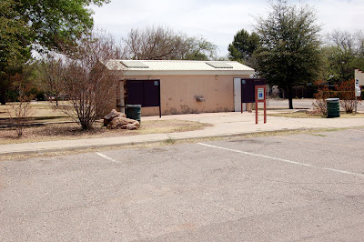
First Impressions #2: Patagonia Public Restrooms

Posted by PicasaWhen your blogger lived in New York City there was a segment on one of the local television stations called "SHAME ON YOU! "

With apologies ahead of time for the grossness of these images taken yesterday, April 27, 2009, this is what both residents - individuals and families - who use the town public park and visitors find approaching and going into the public restrooms prominently located on Fourth Avenue between McKeown and Naugle Avenues . . . see for yourself

Some weeks ago, a call was made from The Visitor Information Center following the complaint of a tourist to the town offices complaining about the dirty and rank conditions in the public restrooms . . . there was no assurance or response that these reported conditions would be looked into, so here for you, dear readers, to look at are what townpeople and visitors see in Patagonia's public restrooms.

Take a look! . . . sorry for not keeping this "hidden"

Tuesday, April 21, 2009

DIGGING INTO HISTORY: Uncovering Oldways Farming

Sometimes is what's you see all around you - the small wonders of Patagonia that might go un-noticed or "hidden" or neglected in the big landscape of The Mountain Empire - and sometimes it's what groups of people are digging into once again: to expose and reveal early cultures living on the land along the water-giving lifeways of The Santa Cruz River and its tributary streams that once flowed on the conflux surfaces here: places like Harshaw Creek along the gateway trails of what are now vacant "Ghost Towns" and places like The Sonoita Valley and Sonoita Creek that winds its way through history starting about eight miles northeast of Patagonia, weaving and carving its way in the ground through streets and through neighborhoods in town, past where the Wastewater Treatment Plant is located now (where people swam on Blue Heaven before it became polluted), on through what is now a riparian habitat restoration area under the land stewardship preserve of The Nature Conservancy, on through what is now The Circle Z Ranch, on to the man-made Lake Patagonia, and on for some twenty-plus miles from there into the 9,000-acre Sonoita Creek Preserve Natural Area.
The video embedded here shows an archeological dig along the banks of the northern reach of The Santa Cruz River in Tucson in the Rio Nuevo area uncovering and exposing evidence in the timeline of history of indigenous or "native" people cultivating foodcrops and living on the land centuries before the Christian and western world's concept of time began on the Georgian Calendar: 1,250 B.C. (before Christ) . . . it's now three thousand years later.
From the many stories told to me, the same evidence of much earlier cultures following the life-giving waterways of the Santa Cruz River in the headwaters rising in The San Rafael Valley and its tributaries like the Sonoita Creek, should be found here to honor and celebrate those that came before - before the lands became "divided" by the Spanish Conquest back in the 15th and 16th Centuries.
We've come a long way down the centuries- all of us who migrated here - but let us "not forget" those forebears who were on this continent before . . . the brave people who dedicated their lives to living on these lands . . . We just need to dig deeper.
Factoid: Santa Cruz County is the only county in Arizona that does not have an "officially recognized" site dedicated to native people.
To-go-to Information:
www.desert.com
www.azpm.org
www.cdarc.org

Sunday, April 19, 2009

First Impressions: Entering Patagonia


In this posting you'll see two "drive-by" Welcome signs at either end of town, and a grouping of other signage after the overpass over Sonoita Creek just before Taylor Avenue on Route 82. Please take a look at the images taken two days ago, just in case they have not come to your attention recently.

The two identical 3 x 5 ft. yellow signs say the same things:
Welcome to Patagonia (that's real nice)
Step Back, Relax, Stay Awhile (that's nice too, but step back into what?]
Highlight one annual event the second weekend in October
Give credit to the Patagonia Area Business Association and a website address
. . . and nothing more, so pull over to the side of the road, stop, and whip out your laptop, IPhone or PDA to get information you can use? Come here once a year?

Surely we can do better.

Keep in mind that these two Welcome signs are what people - both residents and visitors alike - see entering town from the West and the East on a section of State Route 82 called the Scenic Patagonia-Sonoita Highway. If you're not using alternative means of transportation or traveling on backroads and trails, it's the only way into Patagonia from the neighboring towns of Nogales some twenty miles to the south and west, and and twelve miles north and east to Sonoita-Elgin.
Highway signs at town/city lines usually state Entering [Name of Town], Founded/Incorporated [The Year], Population, and Elevation, advise motorists to reduce speed ahead, and have directional signs to assist travelers for finding their way to destinations and points-of-interest, or to services available in the community [public telephone, visitor information, community services, police, or public restrooms for example].

The image of the group of signs shows a mish-mash of information (one of which is the Museum of The Dead recognized by The Smithsonian Institution] and points the way to only two of the five "Ghost Towns" found down the road to the left (?) - no wayfinding information about the town offices or traffic court, post office, fire department, the family health center, the marshal's office, a public telephone or public restrooms, the public library, food and shopping, gas station, visitor information, lodging, the Coronado National Forest, The Arizona Trail, The Tree of Life, The Nature Conservancy Sonoita Creek Preserve, or any other attractions in town.

. . . it's no wonder to me that people say "We're just passing through! . . . that's one of the consequences of calling Patagonia a hidden paradise.
When they do take the time to stop, they want to TO KNOW what there is to see, where to go, what to do, where to eat, where to stay, where to shop, where to relax or where to recreate or where to rejuvenate, where to walk, where to hike, where to bike, where to watch birds, where to go rock-hounding, where to camp, where to ride horses, how to get to somewhere in the area, how to find a guide for birding or hunting or historic destinations, or they simply say, "Tell me about Patagonia".

That's the reasoning behind our working on The Patagonia Heritage Tile Mural Project 2009 . . . those wishing to keep Patagonia "a hidden paradise" have just lost their way: Time to take off the blindfolds and open your eyes to the small wonders of Patagonia in the big landscape of The Mountain Empire
Posted by Picasa

Saturday, April 11, 2009

Places/People/Progress: RIDE THE WEST - HORSE PACK TRIP ADVENTURES IN SOUTHERN ARIZONA

Let's put those three categories in perspective: the places have been here for centuries, people live on the land and progress is made respecting all three for creating a future legacy.
Some more details will be added later, but you might like to see that when you look at the website http://www.ridethewest.com/index.html,
the same person featured in an earlier posting here on a horse called "Howdy" is one of the partners offering packtrips into the big landscapes here.
For those who might get "saddle shy" overnight accommodations are affiliated with two distinct properties, The Esplendor Resort in Rio Rico
www.esplendor_resort.com and Hacienda Corona de Guevavi www.haciendacorona.com in Nogales.
Rides are scheduled on Ride The West's event calendar on their website.
Happy Trails


RIDE THE WEST - HORSE PACK TRIP ADVENTURES IN SOUTHERN ARIZONA

Places, People & Progress: Challenge to Uncovering History

"As Time Goes By . . ."
Look closely, dear readers, at this recent digital image April 2009 taken from the Smelter Alley side of this property located at the intersection of McKeown & 3rd Avenues. WHAT do you see?

Really now, WHAT DO YOU SEE?

This is what residents of Patagonia look at either walking or driving by frequently year-in and year-out --and at the same time what visitors see when they come here: Junk? Overgrown backyard?

What's in there?

These are questions asked to me by visitors when I walked them around the streets of Patagonia.

Some remarked after coming here for many years that certain parts of the town were badly-neglected and had fallen into disrepair and what a sad-and-sorry reflection of the community it was to have this "just happen" . . .

Whose watch did it happen on? . . . or was no one watching at all? Or not caring? Or not, What?

Happily, that's not the case:
Last year some individuals - Ted Piper and Phil Ostrum among them -decided to do something.
They formed Patagonia Green Partnership.
Today you can see the work-in-progress at the same place that used to be at various times in Patagonia's history The Corbett Lumber Company and The Little Depot.
Soon to have an opening is a new business for the new lifeways here: Pilates of Patagonia . . . now that's what I call progress
Posted by Picasa

Wednesday, April 8, 2009

Wayfinding & Landmark Snarfing

Image featured is an equipment van for the Adventure Cycling Association - a group with headquarters in Seattle, Washington - from an overnight stay here a couple of weeks ago in the public park area dedicated to Dr. Delmar Mock for his 37 years of service to the community on a plaque on a stone historic marker at the west entrance to town. They planned their stop here last November asking for a permit for overnight camping from the town clerk Randy Heiss at that time ...new lifeways making use of one Patagonia's many resources. They found their way here . . .
Readers might ask about our Patagonia Heritage Tile Mural Project funded by a grant from the Arizona Office of Tourism Rural Tourism Development Grant Program "So why do we need to work together to develop the opportunities for increasing visitations and tourism here in Patagonia?"
Who benefits directly and indirectly?
Can we afford not to plan for smart and intelligent growth?
Why do visitors want to come here?
Why do we live here? How did you or your family find their way here?
What legacy do we want to create for future generations?
Do we have a sense of pride in the places that are here?
...or is it a matter of "benign neglect"? or wanting to keep Patagonia "a hidden paradise"?

While hosting travelers wanting information who come into the Patagonia-Mountain Empire Visitor Information Center - they WANT TO KNOW locations and directions and find their way to our regional attractions and services available in the communities. Show and tell me what's great about Patagonia ...How do I get to the lake? Where do I find the birds? Where can I go hiking? Where can I stay? What's there to do? Where can I eat? Is there a bank? Where's the library? Where's "a hot zone" for internet access? Is there a notary public in town? How do I get to "The Ghost Towns"? Where can I camp? Where can I bring my horses? Where can I buy stamps/mail a letter?
They still ask about The Museum of The Horse, even though it moved out of town more 20 years ago!
What's surprising to me is that people who have lived as close as Tucson - about one hour away! - for 8, 10 or 20 years have never taken the time before to travel here [lack of regional exposure and marketing], while travelers from as far away as China,Russia, France, Spain, Germany, England, Bulgaria and South Africa do find their reasons to visit here!
The Heritage Tile Mural Project is a primary wayfinding source of information that showcases our community and region, points of interest and attraction, activities and natural resources, visitor services, and encourages landmark restoration and community development in the process.

The link below is to an organization called Historical Marker Database.
Go to it and check if you see anything at all in Patagonia ... -
http://www.hmdb.org/Results.asp?State=Arizona

Likewise --- and this is a somewhat of a surprise - there are major omissions in a map of milestones here in Arizona: go see for yourself
http://www.azpbs.org/arizonastories/milestones.php

Thursday, April 2, 2009

People, Progress & Places in One Legacy Marker

 
To give you an idea of a research target for our Patagonia Heritage Tile Mural Project 2009 take a look at this historical marker for The Mowry Mine.
You'll note that the infamous Sylvester Mowry didn't appear on the scene here until 1859 although his name somehow got attached permanently to this mine that had been worked for centuries before by native labor and Mexicans. So-called "Anglos" wrote that history apparently and dominate our interpretation of what has come before. Mr. Mowry was a Confederate sympathizer during the American Civil War; he was imprisoned for being on the wrong side of that conflict.

The weather-beaten marker is mounted on a locally-quarried fragment of granite in the center of town at the intersection of Naugle & Third Avenue.

Certain facts in the progression of history are better represented than others, leaving gaps in a balanced legacy:

"Worked by NATIVE LABOR" ... We had "natives" here in Patagonia? Did we forget?

"under the direction of Jesuits" . . . Yes, it appears the Black-Robes did more than convert the natives to Christianity

"Later by Mexicans" . . . yes, but how about some more details? . . . and for how long before The Gadsden Purchase in 1853-54?

"Nearby Ghost Towns and Cemetery are reminders of frequent Indian raids" . . . You mean the mines went out of business due to attacks by Indians? HUH? and local residents couldn't defend their lives and properties against raids?
Reminders - for the purposes of accurate local history - should also include the Boom-to-Bust cycles of mining companies and external events outside Arizona.


Who's buried in the local cemetery who was killed by the Indians? Can that be verified? Where are the records and archives located?

And Patagonia was called "a sleepy town"???? . . . Somebody got that all wrong!
And, it appears just by the notations on this legacy marker, that it was never "a hidden paradise"...Not then and not now.

Please join the local working group for the Arizona Centennial Heritage Project - we've got a lot to do
Posted by Picasa